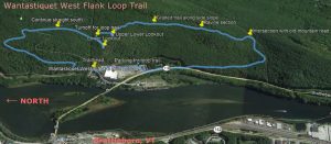
There’s a beautiful, unknown 3-mile loop trail on Wantastiquet. I discovered it a few years ago. I’ve pushed fallen branches to the side, so now it’s sort of possible to follow it. I’ve posted a GPS track “kmz” file here that can be used on a smartphone to help stay on the trail, www.danaxtell.com/Wantastiquet_Flank_Loop.kmz . Google Earth will show this track as an overlay.
The trail goes nowhere near the summit, but does visit the best panoramic lookouts on the mountain—the ones that photographers have been using for 170 years. The loop is possible only because there is a carefully graded trail and retaining wall through the rockslides on the steepest section. I have never seen a mention of this stretch of trail. I found it while exploring the various lookout points in the area. It’s a mystery.
This is the best time of year to explore the trail. The undergrowth isn’t yet hiding the trail and you can still see Brattleboro through the trees for most of the hike. Once the trees leaf out, it’s easy to lose your sense of direction.
I suggest parking in the Georges Field shopping center parking lot. It’s more convenient and more secure than the trailhead parking. I strongly recommend following the trail clockwise. The turns are harder to follow the other way. Also, if everyone goes clockwise, you won’t meet up with other hikers in these CoViD-19 days.
Go north past the trailhead on Mountain Road and then follow the blue-blazed trail for about a mile. At the 6th hairpin turn, go straight where the summit trail curves left. This side trail was originally a two-track road, so it’s fairly easy to follow. It’s also well-used as the path to the lower lookout. It’s mostly downhill.
You cross the stream and pass under the utility lines. 100 feet later, at the height of a small rise, you turn left and scramble up a small ledge. From there, you go up a fairly steep rise and through some thick brush to the upper lower lookout. This is the halfway point in terms of effort.
The trail gets hard to follow now. Continue south to an abandoned encampment and curve left (east) to find where the trail scrambles up a small ledge. There are some fallen branches that line the trail as a clue through here. Continue south, sloping gently up to a larger ledge outcropping. Here the trail is a single worn track that skirts the outcropping. Past the ledge, go downhill, still going south. Soon you’ll get down to the neatly built, level trail section that will take you easily past rock slides. Why this nice bit of engineering exists, I have no idea.
In some places, the trail is so overgrown with mountain laurel that you have to make small detours, but you’re still going south. There are enough clues to follow the trail here in springtime, but here is where a GPS app would be helpful.
You’ll see a ravine start to your left. The trail here follows a little ridge for a while. You’ll be following that ravine eventually. If it’s not too wet, you can start following the ravine at this point. This is the area with that amazing embankment of boulders.
Once the trail takes you down into the ravine (and you can no longer see Brattleboro), your precise route isn’t important, because you’re going to meet the old south mountain road no matter how you follow the ravine. The trail is somewhat marked by branches parallel to it. The trail offers easier footing and swings left as soon as it’s easy and level for meeting up with the old road.
Once you’re on the old road, you just follow it down to Route 119. You have to follow 119 for a quarter mile to get back, but there’s some room beside the pavement, so you don’t have to walk on the pavement or cross to the other side.
By the way, if you turn left on the old south mountain road, you can take a strenuous hike up to the hoax mine and the Mine Ledge Lookout and loop back past the summit. The turnoff for the mine trail is marked with an arrow and then follows the steep ridge.
Google Earth shows a trail up through the ravine, past the white boulders, but that’s a stream, not a path. It is possible to walk up that way, but there’s no trail. The old south mountain road used to continue to the oxbow on Oxbow Road, but it’s now swampy and hard to follow and on private land.
To use the KMZ file, download Google Earth or Green Tracks to your phone and just open the KMZ file. You’ll be able to see when you get off the trail. You don’t need any features fancier than that.
There is no poison ivy on Wantastiquet, but plenty of ticks, so please tuck in your socks and watch for ticks for a couple of days after the hike.

Great trail research
Thanks, Dan, This is great. I was always wondering where some of those old photos had been taken from. This makes sense.
With people looking for outdoor hikes now more than ever, I bet a few people give this a try. Maybe with the extra foot traffic some of the more difficult spots will wear in.