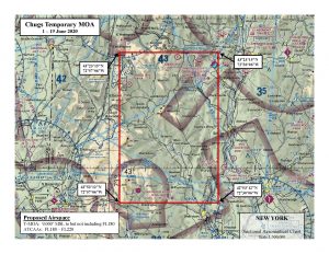
Wondering about the planes buzzing southern Vermont? We asked the VT Air National Guard about it and they weren’t sure where the planes were from at first. After a bit more research, they told us the planes were F-15’s from Massachusetts, and directed us to a page about what they are doing:
SPECIAL USE AIRSPACE
Chugs Temporary Military Operations Area (MOA), Windham, VT
Effective: June 1 – 19, 2020
The Chugs Temporary Military Operations Area (TMOA) will be in effect in the vicinity of Windham, Vermont during the period June 1 – 19, 2020. The purpose of the TMOA is to support exercise Eagle Claw 20-01.
The Eagle Claw exercise is designed to provide training in basic fighter maneuvering and air combat maneuvering (air-to-air combat) in a clean jet configuration to comply with the Air National Guard’s (ANG) training objectives. Clean configuration is defined as no external fuel tanks or pods attached underneath the wings. With no external fuel tanks, the ability for the fighter aircraft to transit long distances to and from other existing special use airspace is severely limited. Establishing the Chugs TMOA that is geographically closer to Barnes ANGB will enable the 104th Fighter Wing to satisfy Air National Guard training requirements.
Projected typical use of the Chugs TMOA is 12 sorties per day, with expected average sortie duration of less than one hour. Use of the TMOA will be from 0830 to 1730 local time daily. During periods when the TMOA is not needed for training, the airspace will be returned to the FAA controlling agency (Boston Air Route Traffic Control Center).
The following is the description and chart of the Chugs TMOA airspace:
Chugs TMOA, Windham, VT
Boundaries. Beginning at lat. 43°23’15″N., long. 72°57’06″W.;
to lat. 43°23’15″N., long. 72°30’06″W.;
to lat. 42°53’12″N., long. 72°30’06″W.;
to lat. 42°53’12″N., long. 72°57’06″W.;
to the point of beginning.
Altitudes. 9,000 feet MSL to but not including FL 180.
Times of use. 0830-1730 local time daily from June 1 – 19, 2020 (estimated 6 hours per day).
Controlling agency. FAA, Boston ARTCC.
Using agency. Air National Guard, 104th FW, Westfield, MA.
Link:
https://www.faa.gov/air_traffic/publications/atpubs/ntap/MIL20001.html?fbclid=IwAR2ajaI010mvNgWFVjI3UkJLfmt5RHdhQYLb1mzD__PwSzn0R6w-Vny30iQ


Temporary Military Operations Area
I was at Haviland’s on Western Ave today and two old military prop planes flew overhead, quite low! Maybe a few hundred feet.
The F-15’s are usually way up there….