 There’s a great driving loop that circles Brattleboro and takes you through some “Real Vermont” country.
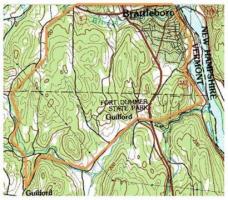
Here’s a map.
1. Start at Main & Canal, by the Food Co-op. Go through Malfunction Jct. and head south down 142 , along the river towards Vernon.
2. After about a mile +/- go right on Broad Brook Rd (Twisty road) to Rt. 5 in Algiers (Guilford).
3. Go right on 5 & quick left on Guilford Center Rd. for about 2 ½ miles. (This is past Fitch Road on the right and Clark Drive on the Left.) Look for some sand piles on the right (Highway Dept.). This is Guilford (Center).
4. Turn right, just beyond piles onto School Rd. Look for Town Office sign. (You will pass the Town Offices and Guilford School on right.) School Rd. becomes Bennett Rd.
5. About ½ mile later, Bennett intersects Bonneyvale Rd. (“T”-intersection). Turn left on Bonneyvale. This is the best part, as it is farmland – what Vermont used to look like. Bonneyvale twists and turns. Be careful at junctions so you stay on it. In about 6 miles you’ll be back in Brattleboro on Western Ave.
6. Turn right on Western to return to town. All told, it’s about 15 miles.
You can also do it backwards, but I know this way better.


"circumnavigating?"
Actually, this is only half way around. Semi-circumnavigating?
I would suggest an extension of the route by turning left on Western Ave. for about 1/4 mile, then right onto Meadowbrook Rd. Up Meadowbrook and down the other side, then turn right on Upper Dummerston Road, and take that to the end at Rte 30. Turn right on Rte 30 to head back into town from the north end on Linden Street.
This extension gives more of the same bucolic scenery that you described, plus some extras – the West Bratt townscape, Brattleboro Country Club, and Grafton Cheese/Retreat Farm.
It is still not quite circumnavigating, but now it’s closer to the complete circle.
Barry
Completing the circle
That would work nicely.